Martin Jean-luc Emile Morlot, Ph.D. Candidate 36th cycle, University of Trento, DICAM
Natural hazards are numerous in the Alps and the Trentino Alto-Adige. Heatwaves, cold waves, landslides, flooding, droughts, are just some of the hazards. Many of these happen to be interconnected, either by one causing another or being coupled. Such multi-hazard events are defined as cascading or compounded. To effectively mitigate compounded hazards, it is important to quantify them, understand their risks, vulnerabilities, exposures, impacts as well as to consider these hazards not only individually but in a grouped manner. This is because mitigating techniques for one hazard might lead to the increase of the impact of another. However, before the interconnection between the hazards can be established, it is important to study them individually and gain a better understanding of each one of them.
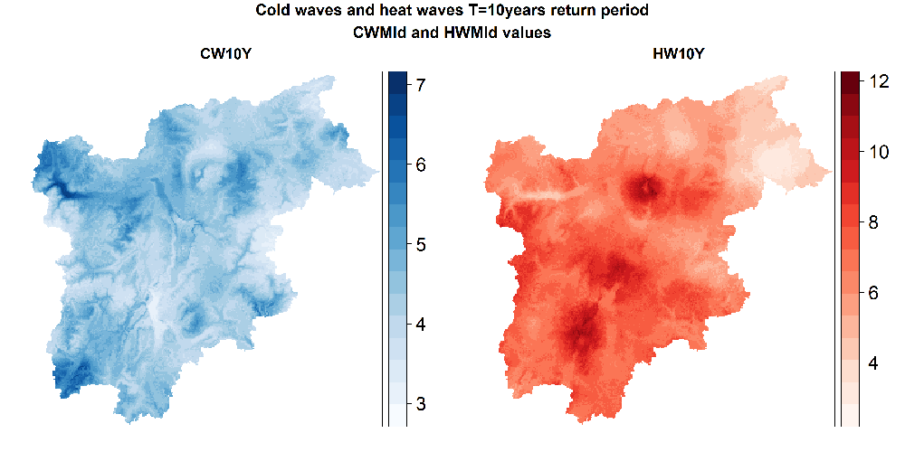
As a starting point, we have calculated, analysed, and discussed changes in the spatial temporal variability of these elements for the risks of Heat waves and Cold Waves for theTrentino-Alto Adige region for the past 4 decades by using a specific framework to quantify the hazards, its return periods, exposures, vulnerabilities, and risks. Trends were statistically tested, when possible, for every element calculated. Overall, statistically significant increasing trends were found for the heat waves’ hazard and exposure whereas those of cold waves were found to remain stagnant. Vulnerability was found to be decreasing throughout the region across the decades except for the region’s larger cities. Finally, the heat waves risks were confirmed to have an increasing significant trend for most of the region and cold waves risks are found have a decreasing significant trend for most of the region. One exception to this is the large cities where they are found to be increasing faster than the average for the case of heat waves risk and increasing for the case of cold waves risk.
To mitigate future hazards, it is also important to understand their future occurrence. With regards to this, historical and projection temperature and precipitation modelled data were obtained at two coarse different resolutions, at the global climate circulation model (GCM) scale and at the regional climate circulation model (RCM) scale. These sources were found to be at too coarse of a resolution to be used at the local level and hence a methodology was used to increase the resolution and found to give good goodness of fit results when comparing the historical modelled data to those of observation data.
Work with regards to the impact of temperatures on mortality is currently being conducted using observed temperatures and the projected temperatures. This is being done in order to analyze past mortality rates and projected rates, and whether an increase or decrease in mortality due to the changing temperatures can be expected.
Work on droughts and floods modelling is also underway. To perform the modelling of floods and droughts, an adapted water resource framework is being used. Currently the framework is being calibrated within the Trentino Alto-Adige region against observations datasets. The goal is to analyze drought and floods occurrence with respect to observed data, as well as future data obtained of the GCM and RCM and model floods and droughts past and future impacts.